Hiking Curacao

The first day we went hiking, we went to Christoffel National Park and followed a trail that was about 5 km total.  In the scrub forest that made up the first third of the hike, we had to nearly crawl under some low branches, and dodge our way around overgrown bushes with wicked thorns.  It was quite the interesting trail.  

_DSC2133.JPG

You end up on the wild east coast of the island.

The trail

The trail

_DSC2139.JPG

The mountain on the left, in the picture above, is Christoffel Mountain - the highest point on the island at just over 1,000 ft.  I had had enough of hiking just to hike, over the last several weeks, so we drove on a loop around it instead.  That was actually pretty neat to see the ground bromeliads brightening up the scrub.

You can see the yellow spiky leaves of the bromeliads, along with the different kinds of cacti.

You can see the yellow spiky leaves of the bromeliads, along with the different kinds of cacti.

A blooming bromeliad

A blooming bromeliad

On the way back to our hotel, we wandered down a road, hoping for a better view of the enormous wind turbines we kept catching glimpses of along the coast.

_DSC2165.JPG

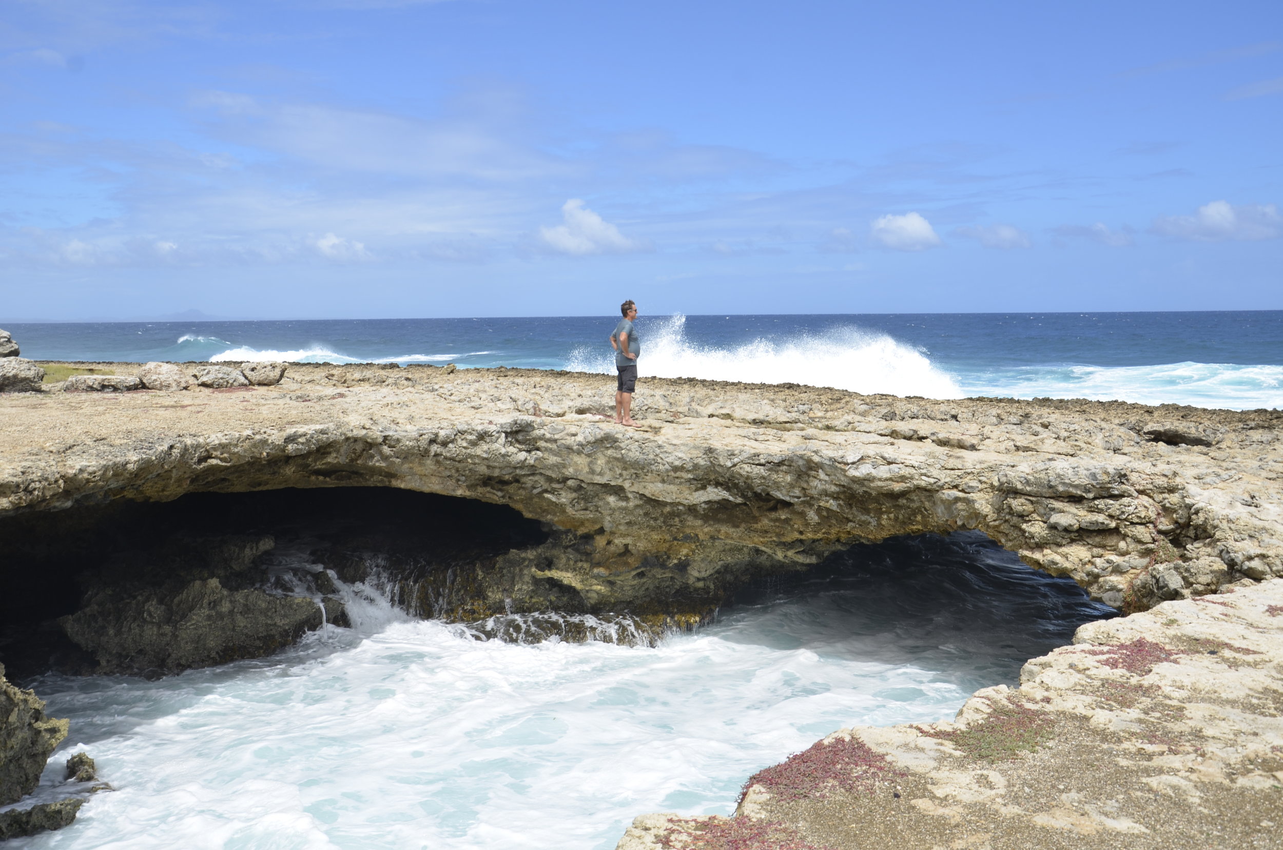
On our second day of hiking, we headed for Westpunt (the western point of the island) to try and find a unique geologic formation that a friend told us about.   GPS actually served us well this time, as we wandered down dirt roads to Watamula Hole.  There were occasional hand-painted signs that reassured us we were heading in the right direction as the road kept deteriorating.  The surf was wild on this edge, and the ground was really sharp pocked limestone.

_DSC2191.JPG

There was a natural arch that was carved by wave action:

_DSC2175.JPG

The Watamula Hole is also called the Eye of Curacao - again, cool limestone formation due to water erosion:

_DSC2172.JPG

The most curious part of the hike was trying to find the Breath of Curacao.  This is what our friend had mentioned, but it's not marked on the shore, and the single mention online was vague as to its location.  It is a geologic formation caused by water erosion under the shore, that as water rushes back and forth, air is expelled from a rift in the stone, making a sighing sound.

_DSC2198.JPG

It was anticlimactic, to say the least, after wandering up and down this ironshore, trying to avoid waves crashing, and the wind pushing you towards the edge. 

On our last day on the island, we wanted to explore the East End, but there are no roads going there, so we settled for the "northeast end", which was also wild with crashing waves.  We again drove on dirt roads to get to this deserted beach, where we found another natural arch.

_DSC2216.JPG

Oh!  Interesting (pallet) fencing seen around the island:

_DSC2211.JPG

And thus draws to a close, the exploration of the southern Caribbean.

_DSC2221.JPG

Curacao

Before talking about this island, I wanted to share "The Ongoing Misadventures of Steve (& Lisa).  Back on Aruba, we had problems with the GPS mapping service trying to get us to drive the wrong way on one way streets (which we did once, much to the consternation and honking of the native Arubians).  Because of this, we ran late getting to the restaurant on our last night there and were unable to find parking anywhere close.  Steve dropped me off to let them know that we were there, and he went off to find parking.  As he walked up, he said that he realized he didn't have his wallet.  The hostess asked for a credit card number (that he had on his phone), but when she tried to run it through the machine by hand, it wouldn't take it.  He was going to let me eat, while he went back to our apt. for his wallet, but the hostess was sweet and said for us to enjoy our dinner, and then email our card number to her when we got back to our room!  He found another card number in his phone (that worked on her machine), and we had a delicious and stress free dinner.  Here in Curacao, we're running into weird GPS issues also, but we've learned to stick to main streets, rather than following the directions and heading down someone's driveway.  I won't go into the evening the GPS quit working altogether -- as we were driving to a restaurant (aarrgghhh).

Our first day on Curacao was spent walking around downtown Willemstad, the capital.  It has a very European feel, mixed with Caribbean influence.

_DSC2003.JPG

There is a harbor that cuts through the middle of "downtown", with the two sides joined by a floating pedestrian bridge.  This opens up to let ocean going ships through, and we were lucky enough to see it swinging open.  While it's open, there's a free ferry on each side to get people across.  As we were wandering through the city, we heard a ship's horn blasting, and caught glimpses of the ship passing by, and it was taller than the buildings!

Queen Emma floating bridge

Queen Emma floating bridge

We also did a tour of the Curacao liqueur factory and learned how to make some cocktails.  The liqueur is made from the peels of Lahara oranges, that are hung in gunny sacks (along with cloves and other spices) in the distilling vat.  Curacao liqueur is actually clear, and they just add blue food coloring (or red or yellow or green) to achieve the color that you usually associate with the drink.

The original still that has been in use since 1896.

The original still that has been in use since 1896.

The next day we drove up the west coast of the island to snorkel (no pictures, sorry - it was nothing like our diving, but still enjoyable) and stopped along the road to peer at some flamingos.  

The different shades of pink were interesting

The different shades of pink were interesting

_DSC2087.JPG

We're going to have a lazy day today.  

_DSC2094.JPG

Natural Aruba

Sheesh.  Aruba usually gets 20 inches of rain a year, and over last night and today, this desert island has probably received one of those inches!  On every island we've been on this trip, the locals keep saying, "but this is the dry season" as we're getting poured on.

Yesterday, we drove over to Arikok National Park and hiked to the east coast of the island.  We hiked a total of 6 miles in blazing sun and gusty winds through a relatively barren landscape.  It was pretty neat.  {We saw only 2 other couples hiking - everyone else (most 30 years younger than us) rode 4X4's through the desert.}

Our starting point

Our starting point

A divi tree along the way

A divi tree along the way

Note the line of windmills at the top of the picture

Note the line of windmills at the top of the picture

_DSC1963.JPG

This was the goal of the hike.  It's called Natural Pool, but it was beyond me how you could swim there.  Apparently at some other time of year, the area just beneath the crashing wave fills enough with water for people to (?)safely swim.

just a cool picture

just a cool picture

We were going to take a selfie, then some nice "kids" came by and offered to take one for us

We were going to take a selfie, then some nice "kids" came by and offered to take one for us

This is actually a tree

This is actually a tree

On the way back

On the way back

Small world: one of the "kids" who took our picture was from Murfreesboro (a town just 20 minutes from Mt. Juliet).  Also, the corn flakes we bought at the Save-a-Lot grocery store came from Earth City, MO (just outside of St. Louis).

We walked around downtown Oranjestad (the capital) today.  Not much to see or photograph, other than the blue horses scattered around as an art installation.

_DSC1989.JPG

I was standing by the "I (heart) Aruba" sign when I took this picture.  I absolutely refused to take a picture of the sign that all the tourists were taking of others and themselves.  BUT, I did take several pictures of these blue horses scattered through downtown.  I guess I am a tourist after all.

This last picture sums up Aruba for me very well (my favorite snorkeling place on the island):

_DSC1908.JPG

Carnival in Aruba - not

I hadn't realized that it was Carnival time when we were booking this trip.  The Caribbean is renowned for its Carnival celebrations - especially Trinidad (one of the top 10 in the world!).  SO glad we didn't stay there.  I was relieved that we'd be on Aruba for the actual "Fat Tuesday", but found out, once we're here, that Monday (?why?) is a national holiday.  There were big parades on the island both Sat. and Sun., but we avoided them very easily.

Sadly, Steve has been sick for the last 3 days, so we haven't done much.  At first we thought it was bad sushi he had in Miami airport, but when his symptoms persisted, accompanied by fever and lethargy, we decided he must have caught the flu from someone in the airport or on the flight.  He's getting better now, and I dragged him out today around the island, so I could get some pictures to share with y'all, as well as us getting "the best" BBQ ribs on the island - they were really tasty.

_DSC1852.JPG

Aruba is VERY windy and dry.  Usually, wind speeds are 22-25 mph constantly, with 35 mph gusts.  In the picture above, the water is getting blown off the top of the waves, from the winds that come off the island.  The dryness is so different from the rainforest islands where we'd spent the last several weeks.  I really like the lack of bugs (mosquitos especially!), but the wind really does start to get to you after awhile.

California lighthouse at the northern end of the island

California lighthouse at the northern end of the island

_DSC1828.JPG

This is the view of the island looking south from the lighthouse.  The signs on the road identify the "high rise" hotels and the "low rise" hotels - 2 totally separate areas along the western coast.

_DSC1880.JPG

This is a public beach where we've gone snorkeling a couple of times.  It's neat that there are permanent thatched palapas available for shade.  The water really is that blue.  Snorkeling has been an interesting experience for us, as we are normally down right next to the fish when we dive, but our bubbles scare them a lot.  So, floating above silently allows us to watch interesting fish behavior that we don't necessarily get to see while diving.

_DSC1701.JPG

We went to the Aruba Butterfly Farm, and learned some very interesting things about these creatures.  Apparently, when fruit sits out/rots, alcohol is produced from the sugars in it, and the butterflies get "drunk".

_DSC1715.JPG

Blue Morpho butterflies are nearly impossible to photograph with their gorgeous wings open.  We had seen them flitting about in the jungles in Peru, but they were everywhere in this butterfly enclosure. 

A semi-decent shot of one approaching another

A semi-decent shot of one approaching another

Various chrysalises (?chrysili?) 

Various chrysalises (?chrysili?) 

We'll be "hanging out" here in Aruba another few days, before moving on to Curacao.

Steve wanted me to send on this video from Tobago of the largest brain coral in the world.

Uploaded by Lisa Jabusch on 2018-02-12.

Tobago thoughts

We're taking our last 2 days in Tobago super easy and just literally sitting!  Well, I am swimming laps in the pool, just to burn some calories, but with all the divin' and drivin' we'd done for the past week, neither of us really want to do any more exploring.  We have to keep reminding ourselves that we are entitled to relax now, and every new place doesn't have to be explored down to the last square inch.

_DSC1469.JPG

This is the beach right near our apartment, and our "landlady" says it's alway this deserted.  It was great to walk along, and see lizards and crabs scuttle away, as well as watch the long, slow rise of water over the shallow bay.  We can hear the waves crashing from our apt. deck.

IMG_20180204_085627.jpg

This is the view of the bay where we dove nearly every day for the last week.  We dove at sites all around those islands.  The big one in back is Little Tobago, where we saw the tropicbirds, and the little ones in front have an interesting history.  Not sure if you can see it in this picture, but there's a small water separation between the islands in the front, and the white patch is a house that Ian Fleming supposedly stayed in, writing the James Bond novels.  Apparently, some of the movies were shot here too.

The town of Speyside that greeted us after every dive.

The town of Speyside that greeted us after every dive.

Now for random thoughts:

On each of the Commonwealth islands we've been on, all the school kids wear uniforms.  As we round the corners on our drive, we come upon new color combinations for each different school.

Whenever we get anything to drink (even water), the straw that's in it has a little paper cap, probably to show it's a new straw.  However, Steve has been joking that labor is so cheap here, that someone is hired to place the paper cap back on straws they are re-using. (yuck, gross...)

Guys walk the streets with machetes (they don't look menacing - I guess they're going to work).

There's no need for alarm clocks here.  I'm up with the sun and birds at 0600.  Also, a guy with a commercial line trimmer started (under our bedroom window) at 0559 - - on Sunday!

_DSC1485.JPG

This land crab appears to be waving -- goodbye until Aruba!

Tobago divin' & drivin'

So far, we really like this island and its people.  Not so much the curvy narrow roads and long distances we have to drive on them.  The guesthouse I chose for us is 14 miles from the dive shop and pier.  That doesn't sound like much for the US, but it takes us an HOUR to drive there.  Steve has been a dear to tackle this every day that we've dove, as I can sit and read.  I found this actually helps keep me calm, so that I don't watch the road and wince every time we come within inches of the rock face or cement barriers (keeping us from sliding off the cliff).

I've found that I just haven't taken nearly as many pictures on this island, as previous ones.  This is probably because the topography is similar to others (volcanic peaks and valleys covered in rainforest) and the tight curves don't allow pictures on the fly, nor stopping for scenic overlooks.

Sunrise from our apartment deck

Sunrise from our apartment deck

The drivers here are quite interesting.  Oncoming cars all seem to want their 2/3 of the road, and don't dare come as close to road edges as Steve does.  It's common to have a car stopped in the driving lane (there are no shoulders) picking up a pedestrian, and it seems to occur frequently around blind corners!  Other cars are just parked in the lane, as the driver sits and visits with friends on the street, or runs into the mini-mart for something.  To pass the stopped car, you have to wait for oncoming traffic to go by, then move fast before your window of opportunity closes with a truck barreling at you spewing black exhaust.

A Jacobin

A Jacobin

The hummingbird feeder at the dive shop provided fascinating diversions while waiting between dives.

Ruby-topaz hummingbird

Ruby-topaz hummingbird

That picture above isn't great on focus, but it showed the gorgeous iridescent colors of the cap and throat.  Those little guys were really skittish and fast, and I was quite lucky to get that shot. 

Red-billed tropicbird

Red-billed tropicbird

We went hiking on an uninhabited island named Little Tobago, where there is one of the largest nesting colonies of tropicbirds in the world.  We were lucky to be able to walk right up to a couple of nests.  It was very interesting that in one, the "chick" was the size of the mother, but didn't have the red bill yet, and the nest right next to it, had a fluffball of a chick.

_DSC1497.JPG

The diving has been really good, but I haven't taken many pictures, as the current makes it difficult sometimes, and the little critters I'm becoming more interested in are quite challenging to get to hold still ;-)

juvenile Queen Angelfish

juvenile Queen Angelfish

One of a pair of octopi wedged under a coral head

One of a pair of octopi wedged under a coral head

Blennies are tiny fish (1 inch long) that live in holes in coral, and stretch out to grab passing stuff in the current.

Bye!

Bye!

Some more Grenada

So, to continue the story from the last post... We did go hiking later that day, and boy was it muddy!  Some people might like the feeling of mud squishing between their toes (in sandals), but I found that I decidedly do not.  Steve kept reminding me that "people pay good money for treatments like this".

_DSC0825.JPG

We hiked to Seven Sisters waterfalls - 3 km round trip - so this felt like nothing to us.  However the conditions were quite different than we've ever tackled before.  Besides wading through mud, we crossed streams where the only option was walking on rocks completely submerged, and setting your foot firmly before lifting the other one, so the current wouldn't knock you off.

The reward

The reward

We watched the guy at the top of the falls (35 ft) approach the edge, back off, approach, back off, for over 10 minutes.  We left after taking pictures, and he still hadn't jumped.

This is the type of road that existed up the middle of the island.

This is the type of road that existed up the middle of the island.

About the roads - actual quote from the Lonely Planet guidebook we've been using for our trip this time: "Driving is technically on the left-hand side of the road, but you can expect buses in particular to be going full bore wherever the hell they want to, with full-beam lights on permanently after dark."  Also, after we had driven on the cow paths that one day, we came across a road sign that said "Drive slowly - broken road ahead" and this was actually posted on a pretty nice road!

The next day, we drove up to the north point of the island (about 1 1/2 hours) to go to a restaurant at an inn that had been highly reviewed.  On the way, we stopped at a rum distillery that was started in 1785, and they still use the same labor intensive methods today.

The original wooden water wheel is still used to drive this original cane pressing machine.

The original wooden water wheel is still used to drive this original cane pressing machine.

_DSC0885.JPG

The hollows above are called coppers, and cane juice is heated to 250 degrees, to evaporate some water, and reach certain levels of sweetness.  The juice is transferred from one copper to another by use of the long handled ladles, that you can see lying over the closest copper.  The coppers are actually at different temperatures due to their proximity to the wood fire under the farthest copper.  Once the juice reaches the desired sweetness, it is transferred by pipes to cement holding tanks for 2 days, where it cools and starts fermenting.  The still where the actual distillation occurs uses some new fangled parts from that country up north:

_DSC0889.JPG

Sugar cane in the background:

_DSC0890.JPG

Our two hour lunch on the north point was heavenly.  Absolutely delicious food served to us on a shaded verandah with constant cooling breezes, and we were the only ones there.

View from our table

View from our table

off the north point

off the north point

We're off to Tobago tomorrow for 10 days (!) for both diving and island exploring.

_DSC0935.JPG

It's raining, it's pouring... (Grenada)

We woke up to overcast skies and drizzle, and it has continued to pour intermittently.  Wouldn't you know, that today we had planned on hiking (sensing a theme?).   So, we can't really tour the island, or even check out the beaches, so we're reading and blogging.  This is our third full day here, and we explored the capital, St. George's, our first day.

_DSC0753.JPG

In the picture above, the main tourist (read cruise ship "cruisers") street is in the bottom left, while the Cathedral of the Immaculate Conception's clock tower is to the right (can anyone guess which religion? ;) ).  The downtown is composed of narrow steep streets that rival San Francisco or towns in Peru.

_DSC0749.JPG

On a hill overlooking both the city, as well as the bay, was a decrepit fort built in the early 1700's, and it afforded excellent views all around, although the grounds were underwhelming.

At the top of a hill in town, this gloved policeman was directing traffic.

At the top of a hill in town, this gloved policeman was directing traffic.

Driving along the western (Caribbean) side of the island, we encountered very narrow, steep and winding roads.  Steve continues to do very well in driving on the "correct" side of the road, and only occasionally causes me to gasp as he drives right on the left edge of the asphalt or skims the concrete curbs that keep us from falling off the side of the ravine.

Yes, that's a 2 lane road.

Yes, that's a 2 lane road.

At one small town, there was a sign that said "By Police Order, Not a Through Street", so we dutifully turned to follow the detour signs.  Well, those signs didn't appear again, to guide us, so we depended on trusty Google Maps.  Big mistake.  We found and drove on "roads" (and that's being very generous with that term) up through the center of the island, that we shared with goats and cows.  Luckily we didn't encounter any other cars, as these tracks were quite literally one lane for miles.  Amazingly, 20 or 30 minutes later, we arrived at our original destination of the chocolate factory, with the car and our nerves (basically) intact.  I don't have any pictures of our expedition, as we were too afraid of stopping, and possibly getting stuck, or not being able to keep the car going straight UP the hill.

This is a "civilized" asphalt road along the coast, but it illustrates the rainforest exuberance.

This is a "civilized" asphalt road along the coast, but it illustrates the rainforest exuberance.

The tours through the nutmeg processing plant and chocolate factory were very interesting and eye-opening.  Nutmeg is still sorted by hand by ladies bent over wooden tables, and better quality nuts are determined by putting a handful in a jar of water, and saving the ones that sink, while discarding the lighter ones that float.  These nuts then have to be dried (again) for 2 days after this sorting method.  They had already been dried for several weeks, after they were shelled.  For shipping, the nuts are put in burlap bags, that are hand sewn closed.

Stencils for spray painting the destination on a bag.

Stencils for spray painting the destination on a bag.

I thought I had died and gone to heaven when we got out of the car at the chocolate factory.  The aroma of chocolate was everywhere.  Again, it was a very quick tour, but very informative.  One of the highlights was tasting a fresh cocoa bean straight out of the pod.  They are covered with a white, somewhat gelatinous substance that tastes sour-sweet.  After that is removed, then the beans are dried and roasted before they are shelled to get at the valuable nibs that are crushed into a paste that makes the chocolate we know and love.  Getting to taste 100% chocolate (without milk or sugar added) was mind blowing.  I thought it would be bitter (like cocoa or baking chocolate) but this was awesome - it was truly the essence of chocolate.  I bought 2 bars.

Cocoa pods hold the beans inside.

Cocoa pods hold the beans inside.

_DSC0811.JPG

Bye from the jungle, for today.

Extra notes on St. Vincent

Steve wanted me to correct some things from the previous post and to include some more pictures.

The correction was on the price of the lobster dinner - it was $22 US for each lobster, not for the two together (oh my!).  He also wanted it made clear that the trail up the volcano was 3 1/2 miles one way - so we hiked 7 miles in about 3 hours (with the 3000 ft elevation gain).

Pictures I forgot in my rush to post last night:

The volcano is hidden in the clouds and mist

The volcano is hidden in the clouds and mist

On the way up - trying to dry out from our soaking

On the way up - trying to dry out from our soaking

IMG_20180121_113505.jpg

This was all we could see of the crater's rim, which is off to the left.  We didn't dare stand on the edge, as the fierce wind could easily have pushed us over.  It took everything we had, standing with our feet planted wide apart, to just be upright.  We waited about 10 minutes, to see if the skies might miraculously clear, but no luck.

We do plan on returning to this island, and we will make another assault on Mt. Soufriere in clear weather!

_DSC0718.JPG

Goodbye, from another day in paradise!

St. Vincent, the island

I wanted to share some pictures and stories from exploring the island, other than our diving.  This was very limited, compared to Barbados, but I think I got some neat shots.

Some buddies we had while dining on the hotel porch:

He was looking for either crabs or fish at the water's edge

He was looking for either crabs or fish at the water's edge

_DSC0578.JPG

We hired a taxi to drive us to the volcano, Mt. Soufriere, to hike up it, and I got some pictures of the wild Atlantic side of the island, as well as the colorful buildings and many palm trees that make up this beautiful space.

Each building was painted a different pastel

Each building was painted a different pastel

The beaches are mostly black sand, from the volcano.

The beaches are mostly black sand, from the volcano.

Speaking of Mt. Soufriere (meaning "sulfur"), we started hiking up the 3 1/2 mile trail under overcast skies, which soon opened up into a downpour.  It is, after all, a rain forest, so we kept trudging along.  Very soon, I was feeling very squishy in my soaked socks and shoes (is there anything more disgusting/frustrating?).  Because of the rain, we got very few pictures.

_DSC0664.JPG

After 1 hr 45 min of hiking (gaining 3000 ft), we reached the crater rim to see... nothing.  Gale force winds were trying to blow us over the edge, and the clouds filled the crater.  We had condensation on our eyelashes, while Steve and the guide also had it on their beard whiskers.  What we were supposed to see was:

trekking-la-soufriere-crater.jpg

Ah well, we wrote it off to a good morning of exercise.  We celebrated with a grilled lobster dinner ($22 US for the two of us!) and a number of drinks (we're not telling).  I don't think everything will be dry by morning when we have to pack up for Grenada, but we'll make the best of it.

From the beach in front of our hotel

From the beach in front of our hotel

_DSC0559.JPG

St. Vincent (& the Grenadines)

We're staying on the main island of St. Vincent, for diving, but I'm already planning on coming back next year, for us to hire a sailboat or catamaran and sail around all the Grenadines for a few weeks.

I've been "grounded" from diving for today and tomorrow :-(  because I developed skin bends yesterday after diving.  This is a very mild form of decompression sickness, and was quickly treated by the dive shop.  I breathed pure O2 for an hour (and the symptoms of itchy, painful rash disappeared within 30 minutes).  It was really hard psychologically to wave goodbye to Steve at the boat dock this morning and walk back to the hotel alone.  I made the best of it, though, and swam in the bay, walked the beach for exercise (and sun), and now I'm writing this.  Tomorrow will be a repeat.  I did get some neat pictures and videos, so I'll be posting those today, and in another post in a few days.

Coral banded shrimp

Coral banded shrimp

Those are adult spotted drums.  Steve shot the next video of juvenile ones (and it's at half speed because the little ones swim so frantically) - note how they REALLY change body shape and coloration as they mature.

DSCI0805 crop.jpg

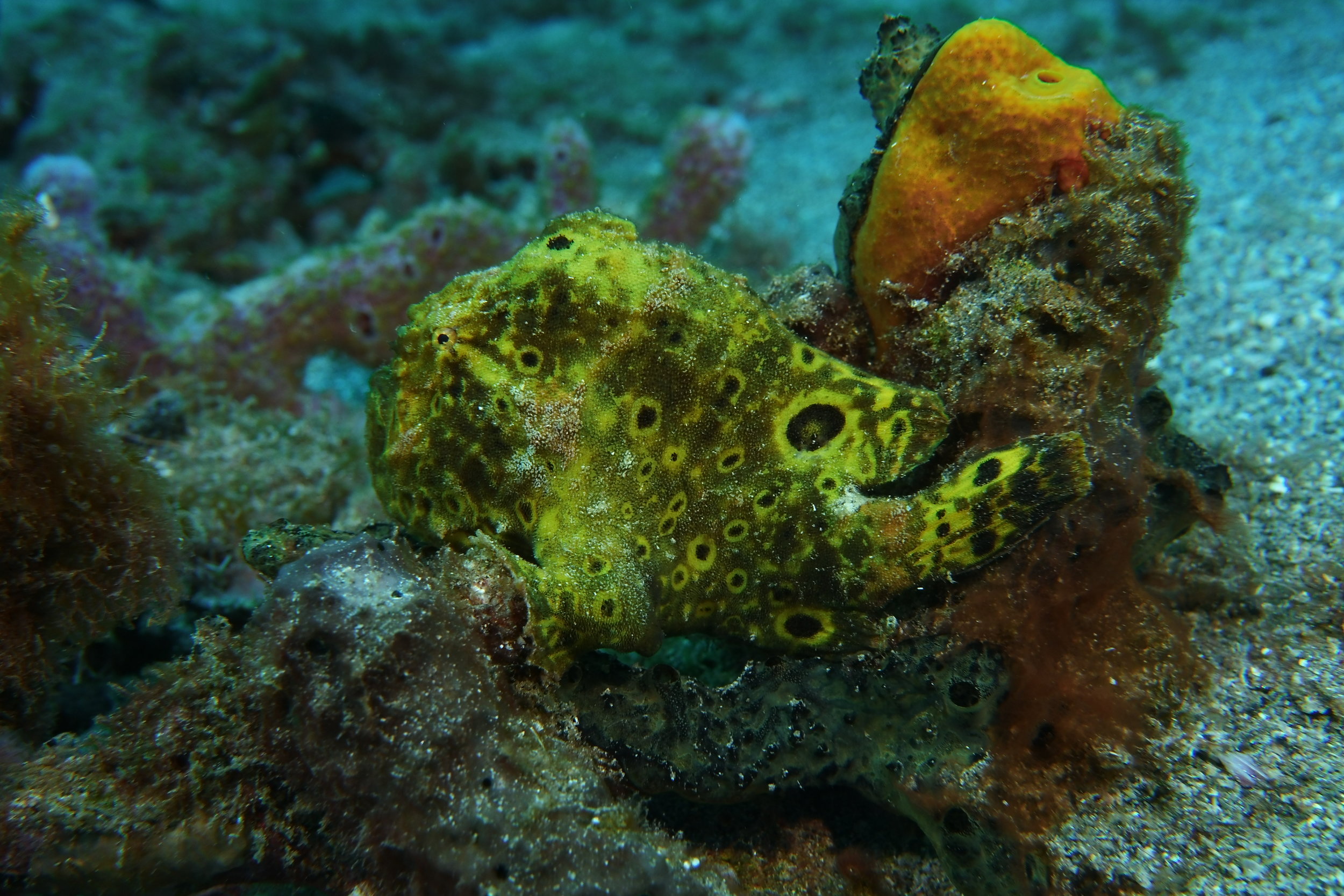
This is a frogfish.  They sit motionless until they snatch an unwary fish that swims too close.  They very closely resemble sponges, and usually blend in better than this guy.  The next one is more tricky.  See if you can spy his little eye (and then make out the similar outline of his body and fins, to the one above).  Hint: he's facing the opposite direction of the one above.

DSCI0807.JPG
This Goldspotted Eel was out hunting in the seagrass (we had never seen one before).

This Goldspotted Eel was out hunting in the seagrass (we had never seen one before).

Other masters of camoflage:

Peacock Flounder up close (to see the detail of his eyes and mouth)

Peacock Flounder up close (to see the detail of his eyes and mouth)

This octopus is pretty tricky - find the small eye in the center, then you can see the siphon just behind it, and suckers on the tentacles to the right.

This octopus is pretty tricky - find the small eye in the center, then you can see the siphon just behind it, and suckers on the tentacles to the right.

DSCI0934 crop.jpg

This little crab deep in a sponge, is Zen like me, and says, "see ya later, mon".

Wild Barbados

The title refers to the rugged north and east coasts, rather than Steve's driving.  He did VERY well and caught on to driving on the left quite quickly, and loved using the roundabouts.  Drivers here know how to use them, and traffic moves so much better than with traffic lights.

Our favorite place on the island was the north point, where the Atlantic and Caribbean meet.  We ate lunch in a cafe perched on land's end, and both the food and views were stupendous.

_DSC0386.JPG

There was a cave below the cafe that gave unique views out to sea

_DSC0410.JPG

Only Eric or Jaclyn (our rock climbing duo) would be able to sit on this bench:

IMG_20180114_142341.jpg

The whole east side of the island was rugged and gave me beautiful pictures.

Sunday afternoon

Sunday afternoon

_DSC0545.JPG

We saw some interesting signs whilst (as the Brits here say) driving around:

We'd see a collection of signs like this at nearly every crossroads

We'd see a collection of signs like this at nearly every crossroads

IMG_20180114_173942.jpg

Farewell from Barbados...

_DSC0539.JPG

Barbados

Hot and humid but beautiful, and with tall, friendly people - Barbados in a nutshell.

_DSC0496.JPG

Our first day we just took a local minibus ($1 fare each) into the capital, Bridgetown and wandered around.   

Food stands were frequent all around the island.

Food stands were frequent all around the island.

_DSC0333.JPG

Beaches, like the one above, were nearly constant on the west (Caribbean) side of the island, and the water was warm (and felt silky).

On our next two days, we had a rental car and drove nearly all around the entire island.  Buildings are brightly painted in pastels, and varied from quite old to extremely pricey.

Speightstown (sounds like "Spice Town" when the locals say it)

Speightstown (sounds like "Spice Town" when the locals say it)

A (?)hotel in Holetown, where the rich people play

A (?)hotel in Holetown, where the rich people play

There was a gorgeous nature park in the center of the island called Welchman Hall Gully (that we dubbed Fern Gully).  We took an hour and a half strolling along the 3/4 mile path and back, taking pictures and learning about all the flora on the island that gets saved in these gullies due to rainfall and other special conditions.

the black blob is a termite nest

the black blob is a termite nest

sleeping off last night's rum punches?

sleeping off last night's rum punches?

At first I thought these chickens were dead, but closer inspection proved that they were breathing and blinking.  I've never seen them lying on their sides before, but I guess they were enjoying the sun.

_DSC0469.JPG

St. Nicholas Abbey is only 1 of 3 Jacobean mansions left in the western hemisphere, and it was built in 1680.  There is a rum distillery on site and the fields surrounding the house are filled with sugar cane.

In the public restroom was this early flush toilet made by the Thomas Crapper company:

(it worked just fine)

(it worked just fine)

_DSC0478.JPG

This is a fitting end for this post.  Next one will be more of the rugged countryside on the north and east sides of the island.  A peak from a hill near the Abbey:

_DSC0483.JPG

Cozumel part 2

The weather warmed up nicely for our last 2 days, and the sun was out all day!  I believe a record low was hit in Cozumel one of the nights we were there, about 66 degrees, and everyone was wearing winter coats and hats!  It was pretty chilly, especially with the constant wind there, and the sun behind the clouds.  That was the day that the water felt so warm and comfortable when we fell in.

The Splendid Toadfish is found only in Cozumel.

The Splendid Toadfish is found only in Cozumel.

this crab was hiding deep under a ledge of coral

this crab was hiding deep under a ledge of coral

divemaster's hand near a spotted moray to show scale

divemaster's hand near a spotted moray to show scale

DSCI0721.JPG

Like this octopus hoarding his conch shell, hug your loved ones tight!  We'll post again from Barbados in a few days.

Ahhh, Cozumel

After a LONG day of travel (up at 0330 and arrive at 7 pm), I was treated to my Happy Meal:

IMG_20180104_201306.jpg

Even though it's cooler than I'd prefer (it's low 70's and windy), it's still sunny and the water's warm (80!).  We drove around the island yesterday because the dive boat didn't go out, so we enjoyed the sun and beautiful blues of the water from the shore.

_DSC0307.JPG

Our first day of diving today was pretty neat, with all our new gear working well, and the water a LOT warmer than the cool, rainy day we left on the boat.

This spotted eel greeted us soon after entry

This spotted eel greeted us soon after entry

Juvenile spotted drum - body the size of your thumbnail

Juvenile spotted drum - body the size of your thumbnail

French angelfish is bigger than a dinner platter

French angelfish is bigger than a dinner platter

We continue diving the next few mornings, and sunning and reading in the afternoons.  I may post again before we leave Cozumel for Barbados, if we get some neat underwater photos.